Florida is preparing for what might be its largest evacuation in seven years as Hurricane Milton intensifies over warm waters and approaches key population centers such as Tampa and Orlando.
This comes just a week after Hurricane Helene blew into the southeast of the USA leaving over 230 dead.
According to the National storm Center, Hurricane Milton was “moving erratically eastward through the southern Gulf of Mexico” early Monday morning and was expected to strengthen into a major storm later that day.
Authorities in Florida are now gearing up for one of the biggest evacuations in years.
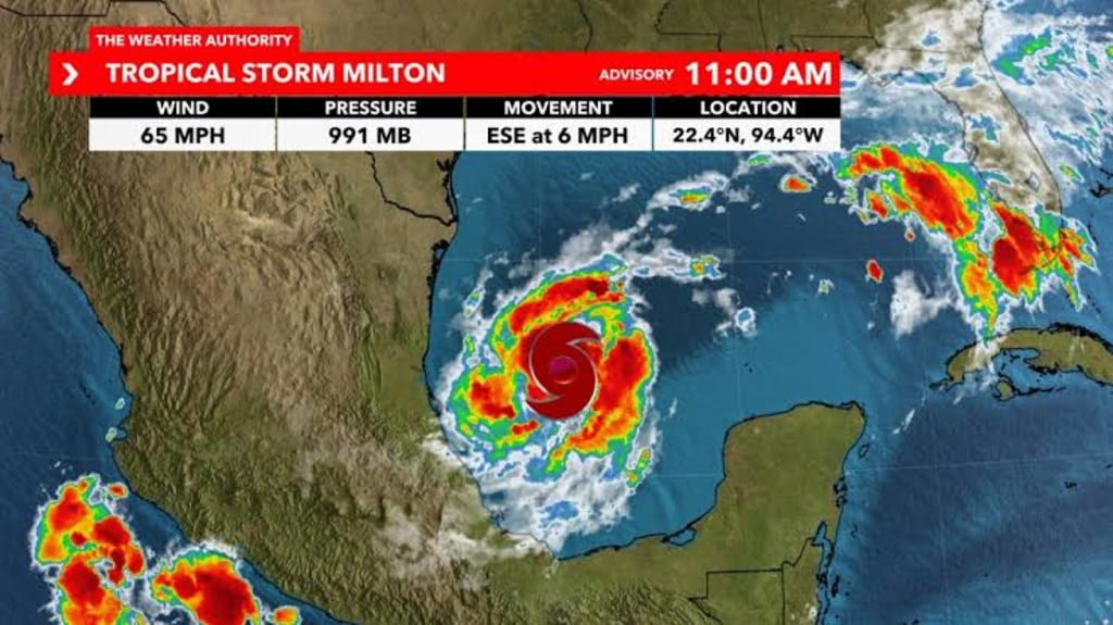
The most likely course, despite the vast variations in forecast models, indicates that Milton may make landfall in the Tampa Bay region on Wednesday and continue to strengthen into a hurricane when it crosses central Florida and into the Atlantic Ocean.
Some of the Carolinas’ most severely damaged areas, which are still recovering from some of the worst flooding in recent memory, would be spared if that route was taken.
The Yucatan Peninsula in Mexico, the Florida Peninsula, the Florida Keys, and the northwest Bahamas were identified by the National Hurricane Center as the regions most likely to be affected by Milton.
Heavy rainfall fell over much of Florida on Sunday as Milton approached.

Florida Governor Ron DeSantis said on Sunday that while it remains to be seen where Milton will strike, it’s clear the state is going to be hit hard.
With Milton achieving hurricane status, this is the first time the Atlantic has had three simultaneous hurricanes after September, according to Colorado State University hurricane scientist Phil Klotzbach.
There have been four simultaneous hurricanes in August and September.
Officials in Tampa opened all city garages free of charge to residents hoping to protect their cars from floodwaters, including electric vehicles.
Hurricane Milton is intensifying rapidly and will likely be a major hurricane before slamming into the storm-ravaged Gulf Coast midweek.
Florida is preparing for what might be its largest evacuation in seven years as Hurricane Milton intensifies over warm waters and approaches key population centers such as Tampa and Orlando.
This comes just a week after Hurricane Helene blew into the southeast of the USA leaving over 230 dead.
According to the National storm Center, Hurricane Milton was “moving erratically eastward through the southern Gulf of Mexico” early Monday morning and was expected to strengthen into a major storm later that day.
Authorities in Florida are now gearing up for one of the biggest evacuations in years.

The most likely course, despite the vast variations in forecast models, indicates that Milton may make landfall in the Tampa Bay region on Wednesday and continue to strengthen into a hurricane when it crosses central Florida and into the Atlantic Ocean.
Some of the Carolinas’ most severely damaged areas, which are still recovering from some of the worst flooding in recent memory, would be spared if that route was taken.
The Yucatan Peninsula in Mexico, the Florida Peninsula, the Florida Keys, and the northwest Bahamas were identified by the National Hurricane Center as the regions most likely to be affected by Milton.
Heavy rainfall fell over much of Florida on Sunday as Milton approached.

Florida Governor Ron DeSantis said on Sunday that while it remains to be seen where Milton will strike, it’s clear the state is going to be hit hard.
With Milton achieving hurricane status, this is the first time the Atlantic has had three simultaneous hurricanes after September, according to Colorado State University hurricane scientist Phil Klotzbach.
There have been four simultaneous hurricanes in August and September.
Officials in Tampa opened all city garages free of charge to residents hoping to protect their cars from floodwaters, including electric vehicles.
Hurricane Milton is intensifying rapidly and will likely be a major hurricane before slamming into the storm-ravaged Gulf Coast midweek.
Florida is preparing for what might be its largest evacuation in seven years as Hurricane Milton intensifies over warm waters and approaches key population centers such as Tampa and Orlando.
This comes just a week after Hurricane Helene blew into the southeast of the USA leaving over 230 dead.
According to the National storm Center, Hurricane Milton was “moving erratically eastward through the southern Gulf of Mexico” early Monday morning and was expected to strengthen into a major storm later that day.
Authorities in Florida are now gearing up for one of the biggest evacuations in years.

The most likely course, despite the vast variations in forecast models, indicates that Milton may make landfall in the Tampa Bay region on Wednesday and continue to strengthen into a hurricane when it crosses central Florida and into the Atlantic Ocean.
Some of the Carolinas’ most severely damaged areas, which are still recovering from some of the worst flooding in recent memory, would be spared if that route was taken.
The Yucatan Peninsula in Mexico, the Florida Peninsula, the Florida Keys, and the northwest Bahamas were identified by the National Hurricane Center as the regions most likely to be affected by Milton.
Heavy rainfall fell over much of Florida on Sunday as Milton approached.

Florida Governor Ron DeSantis said on Sunday that while it remains to be seen where Milton will strike, it’s clear the state is going to be hit hard.
With Milton achieving hurricane status, this is the first time the Atlantic has had three simultaneous hurricanes after September, according to Colorado State University hurricane scientist Phil Klotzbach.
There have been four simultaneous hurricanes in August and September.
Officials in Tampa opened all city garages free of charge to residents hoping to protect their cars from floodwaters, including electric vehicles.
Hurricane Milton is intensifying rapidly and will likely be a major hurricane before slamming into the storm-ravaged Gulf Coast midweek.
Florida is preparing for what might be its largest evacuation in seven years as Hurricane Milton intensifies over warm waters and approaches key population centers such as Tampa and Orlando.
This comes just a week after Hurricane Helene blew into the southeast of the USA leaving over 230 dead.
According to the National storm Center, Hurricane Milton was “moving erratically eastward through the southern Gulf of Mexico” early Monday morning and was expected to strengthen into a major storm later that day.
Authorities in Florida are now gearing up for one of the biggest evacuations in years.

The most likely course, despite the vast variations in forecast models, indicates that Milton may make landfall in the Tampa Bay region on Wednesday and continue to strengthen into a hurricane when it crosses central Florida and into the Atlantic Ocean.
Some of the Carolinas’ most severely damaged areas, which are still recovering from some of the worst flooding in recent memory, would be spared if that route was taken.
The Yucatan Peninsula in Mexico, the Florida Peninsula, the Florida Keys, and the northwest Bahamas were identified by the National Hurricane Center as the regions most likely to be affected by Milton.
Heavy rainfall fell over much of Florida on Sunday as Milton approached.

Florida Governor Ron DeSantis said on Sunday that while it remains to be seen where Milton will strike, it’s clear the state is going to be hit hard.
With Milton achieving hurricane status, this is the first time the Atlantic has had three simultaneous hurricanes after September, according to Colorado State University hurricane scientist Phil Klotzbach.
There have been four simultaneous hurricanes in August and September.
Officials in Tampa opened all city garages free of charge to residents hoping to protect their cars from floodwaters, including electric vehicles.
Hurricane Milton is intensifying rapidly and will likely be a major hurricane before slamming into the storm-ravaged Gulf Coast midweek.
Florida is preparing for what might be its largest evacuation in seven years as Hurricane Milton intensifies over warm waters and approaches key population centers such as Tampa and Orlando.
This comes just a week after Hurricane Helene blew into the southeast of the USA leaving over 230 dead.
According to the National storm Center, Hurricane Milton was “moving erratically eastward through the southern Gulf of Mexico” early Monday morning and was expected to strengthen into a major storm later that day.
Authorities in Florida are now gearing up for one of the biggest evacuations in years.

The most likely course, despite the vast variations in forecast models, indicates that Milton may make landfall in the Tampa Bay region on Wednesday and continue to strengthen into a hurricane when it crosses central Florida and into the Atlantic Ocean.
Some of the Carolinas’ most severely damaged areas, which are still recovering from some of the worst flooding in recent memory, would be spared if that route was taken.
The Yucatan Peninsula in Mexico, the Florida Peninsula, the Florida Keys, and the northwest Bahamas were identified by the National Hurricane Center as the regions most likely to be affected by Milton.
Heavy rainfall fell over much of Florida on Sunday as Milton approached.

Florida Governor Ron DeSantis said on Sunday that while it remains to be seen where Milton will strike, it’s clear the state is going to be hit hard.
With Milton achieving hurricane status, this is the first time the Atlantic has had three simultaneous hurricanes after September, according to Colorado State University hurricane scientist Phil Klotzbach.
There have been four simultaneous hurricanes in August and September.
Officials in Tampa opened all city garages free of charge to residents hoping to protect their cars from floodwaters, including electric vehicles.
Hurricane Milton is intensifying rapidly and will likely be a major hurricane before slamming into the storm-ravaged Gulf Coast midweek.
Florida is preparing for what might be its largest evacuation in seven years as Hurricane Milton intensifies over warm waters and approaches key population centers such as Tampa and Orlando.
This comes just a week after Hurricane Helene blew into the southeast of the USA leaving over 230 dead.
According to the National storm Center, Hurricane Milton was “moving erratically eastward through the southern Gulf of Mexico” early Monday morning and was expected to strengthen into a major storm later that day.
Authorities in Florida are now gearing up for one of the biggest evacuations in years.

The most likely course, despite the vast variations in forecast models, indicates that Milton may make landfall in the Tampa Bay region on Wednesday and continue to strengthen into a hurricane when it crosses central Florida and into the Atlantic Ocean.
Some of the Carolinas’ most severely damaged areas, which are still recovering from some of the worst flooding in recent memory, would be spared if that route was taken.
The Yucatan Peninsula in Mexico, the Florida Peninsula, the Florida Keys, and the northwest Bahamas were identified by the National Hurricane Center as the regions most likely to be affected by Milton.
Heavy rainfall fell over much of Florida on Sunday as Milton approached.

Florida Governor Ron DeSantis said on Sunday that while it remains to be seen where Milton will strike, it’s clear the state is going to be hit hard.
With Milton achieving hurricane status, this is the first time the Atlantic has had three simultaneous hurricanes after September, according to Colorado State University hurricane scientist Phil Klotzbach.
There have been four simultaneous hurricanes in August and September.
Officials in Tampa opened all city garages free of charge to residents hoping to protect their cars from floodwaters, including electric vehicles.
Hurricane Milton is intensifying rapidly and will likely be a major hurricane before slamming into the storm-ravaged Gulf Coast midweek.
Florida is preparing for what might be its largest evacuation in seven years as Hurricane Milton intensifies over warm waters and approaches key population centers such as Tampa and Orlando.
This comes just a week after Hurricane Helene blew into the southeast of the USA leaving over 230 dead.
According to the National storm Center, Hurricane Milton was “moving erratically eastward through the southern Gulf of Mexico” early Monday morning and was expected to strengthen into a major storm later that day.
Authorities in Florida are now gearing up for one of the biggest evacuations in years.

The most likely course, despite the vast variations in forecast models, indicates that Milton may make landfall in the Tampa Bay region on Wednesday and continue to strengthen into a hurricane when it crosses central Florida and into the Atlantic Ocean.
Some of the Carolinas’ most severely damaged areas, which are still recovering from some of the worst flooding in recent memory, would be spared if that route was taken.
The Yucatan Peninsula in Mexico, the Florida Peninsula, the Florida Keys, and the northwest Bahamas were identified by the National Hurricane Center as the regions most likely to be affected by Milton.
Heavy rainfall fell over much of Florida on Sunday as Milton approached.

Florida Governor Ron DeSantis said on Sunday that while it remains to be seen where Milton will strike, it’s clear the state is going to be hit hard.
With Milton achieving hurricane status, this is the first time the Atlantic has had three simultaneous hurricanes after September, according to Colorado State University hurricane scientist Phil Klotzbach.
There have been four simultaneous hurricanes in August and September.
Officials in Tampa opened all city garages free of charge to residents hoping to protect their cars from floodwaters, including electric vehicles.
Hurricane Milton is intensifying rapidly and will likely be a major hurricane before slamming into the storm-ravaged Gulf Coast midweek.
Florida is preparing for what might be its largest evacuation in seven years as Hurricane Milton intensifies over warm waters and approaches key population centers such as Tampa and Orlando.
This comes just a week after Hurricane Helene blew into the southeast of the USA leaving over 230 dead.
According to the National storm Center, Hurricane Milton was “moving erratically eastward through the southern Gulf of Mexico” early Monday morning and was expected to strengthen into a major storm later that day.
Authorities in Florida are now gearing up for one of the biggest evacuations in years.

The most likely course, despite the vast variations in forecast models, indicates that Milton may make landfall in the Tampa Bay region on Wednesday and continue to strengthen into a hurricane when it crosses central Florida and into the Atlantic Ocean.
Some of the Carolinas’ most severely damaged areas, which are still recovering from some of the worst flooding in recent memory, would be spared if that route was taken.
The Yucatan Peninsula in Mexico, the Florida Peninsula, the Florida Keys, and the northwest Bahamas were identified by the National Hurricane Center as the regions most likely to be affected by Milton.
Heavy rainfall fell over much of Florida on Sunday as Milton approached.

Florida Governor Ron DeSantis said on Sunday that while it remains to be seen where Milton will strike, it’s clear the state is going to be hit hard.
With Milton achieving hurricane status, this is the first time the Atlantic has had three simultaneous hurricanes after September, according to Colorado State University hurricane scientist Phil Klotzbach.
There have been four simultaneous hurricanes in August and September.
Officials in Tampa opened all city garages free of charge to residents hoping to protect their cars from floodwaters, including electric vehicles.
Hurricane Milton is intensifying rapidly and will likely be a major hurricane before slamming into the storm-ravaged Gulf Coast midweek.


