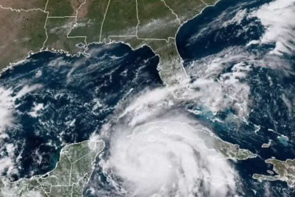
Tropical Storm Helene was swiftly strengthening in the Caribbean Sea and was projected to turn into a hurricane on Wednesday as it moved north along Mexico’s coast into the United States.
Residents were evacuated, schools were closed, and officials in Florida and Georgia declared states of emergency.
The storm is expected to be near hurricane strength when it approaches Mexico’s Yucatan Peninsula early Wednesday, and to intensify and grow in size” as it proceeds north across the Gulf of Mexico.
Heavy rainfall was forecast for the southeastern US starting on Wednesday, with a “life-threatening storm surge” along the entire west coast of Florida, according to the centre.
Helene is expected to become a major hurricane — a Category 3 or higher — on Thursday, the day it is set to reach Florida’s Gulf Coast, according to the hurricane centre.
The centre has issued hurricane warnings for part of Mexico’s Yucatan Peninsula and Florida’s northwestern coastline, where large storm surges of up to 15 feet (4.5 metres) were expected.
Mexico is still reeling from former Hurricane John battering its other coast. John hit the country’s southern Pacific coast late on Monday, killing two people, blowing tin roofs off houses, triggering mudslides and toppling scores of trees, officials said.
John grew into a Category 3 hurricane in a matter of hours on Monday and made landfall about 80 miles (128km) east of the resort of Acapulco, near the town of Punta Maldonado, with maximum sustained winds of 120mph (193kph) before weakening to a tropical storm after moving inland.
Helene, which formed on Tuesday in the Caribbean, is expected to move over deep, warm waters, fuelling its intensification. People in regions under hurricane warnings and watches should be prepared to lose power and should have enough food and water for at least three days, forecasters warned.
Helene was about 45 miles (75 kilometers) east-northeast of Cozumel, Mexico, and 120 miles (190 kilometers) southwest of Cuba’s western coast early Wednesday, moving northwest at 9 mph (15 kilometers per hour).
Early Wednesday, tropical storm warnings were in force for the upper Florida Keys, the southern Florida Peninsula, and Florida’s northeast coast. A tropical storm watch was issued for the South Carolina coast between the Savannah River and the South Santee River.
The hurricane center has issued hurricane watches (a step down from warnings) for sections of western Cuba and Florida, including the Tampa Bay area.
Several counties along Florida’s western and northwest shores have issued evacuation orders. Multiple school districts, including those around Tampa and the state capital Tallahassee, are to close or decrease hours beginning Wednesday.
Some residents started filling sandbags ahead of anticipated flooding and began leaving areas on the coast.
US President Joe Biden declared an emergency in Florida and deployed Federal Emergency Management Agency teams to Florida and Alabama to support local first responders.
Federal authorities were positioning generators, food and water, along with search-and-rescue and power restoration teams, the White House said.
Florida Governor Ron DeSantis also issued an emergency for most of the state’s counties, while Georgia Governor Brian Kemp declared an emergency in his state as well.
The storm is anticipated to be unusually large and fast-moving, meaning storm surges, wind and rain will likely extend far from the storm’s centre, the hurricane centre said. States as far inland as Tennessee, Kentucky and Indiana could see rainfall.
Since the start of the Atlantic hurricane season on June 1, Helene is the sixth named storm. A Colorado State University hurricane researcher named Philip Klotzbach claims that eight significant hurricanes have made landfall in Florida since 2000.
Because of the record-warm ocean temperatures this year, the National Oceanic and Atmospheric Administration has forecast an above-average Atlantic hurricane season. Before the season finishes on November 30, it predicted 17 to 25 named storms, with four to seven major hurricanes of Category 3 or higher.


